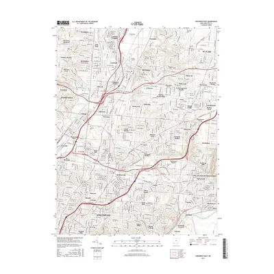
2016 Map of Cincinnati East
USGS Topo · Published 2016About this map
The Little Miami River and Mill Creek define the eastern and western corridors of this suburban landscape as it appeared in 2016. The densely developed terrain between these waterways is a patchwork of established neighborhoods and independent municipalities, including Blue Ash, Reading, and Wyoming. Higher education and regional history are well-represented by the sprawling campus of Xavier Univ and numerous memorial sites such as Rest Haven Memorial Park and Mount Notre Dame Cem.
Find a feature on this map
89 named features on this map. Tap any name to fly to it.
Don’t see what you’re looking for? This feature index may not catch every label — zoom into the map to look around manually.
Map Details
Editions of this 2016 Cincinnati East Map
This is the sole edition of this map. No revisions or reprints were ever made.
Other maps of this area

1898 · East Cincinnati
USGS Topo · 1:62,500
1904 · Mason
USGS Topo · 1:62,500
1906 · Mason
USGS Topo · 1:62,500

1914 · East Cincinnati
USGS Topo · 1:62,500

1914 · West Cincinnati
USGS Topo · 1:62,500
1915 · Hamilton
USGS Topo · 1:62,500
1917 · Hamilton
USGS Topo · 1:62,500
1950 · Covington
USGS Topo · 1:24,000
1952 · Newport
USGS Topo · 1:24,000
1953 · Withamsville
USGS Topo · 1:24,000