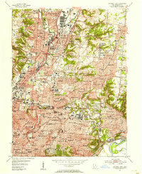
1953 Map of Cincinnati East
USGS Topo · Published 1955About this map
Industrial and residential development defines the eastern landscape of Cincinnati and Norwood during the early 1950s. The dense corridor along Mill Creek reveals the heavy presence of rail lines like the Baltimore and Ohio, serving the manufacturing hub of Ivorydale. Cultural and institutional anchors are prominent throughout the urban fabric, including Xavier University, the University of Cincinnati Observatory, and the expansive grounds of Longview State Hospital. The map reveals the intricate network of neighborhoods stretching from St. Bernard to the suburban fringes of Amberley and Indian Hill, where the terrain shifts toward more open country clubs and parks. Religious and educational history is reflected in the numerous parochial sites such as Mt Notre Dame Academy and St Clare Convent, alongside public landmarks like Walnut Hills High Sch.
Find a feature on this map
116 named features on this map. Tap any name to fly to it.
Don’t see what you’re looking for? This feature index may not catch every label — zoom into the map to look around manually.
Map Details
Editions of this 1953 Cincinnati East Map
This is the sole edition of this map. No revisions or reprints were ever made.
Other maps of this area

1898 · East Cincinnati
USGS Topo · 1:62,500

1904 · Mason
USGS Topo · 1:62,500

1906 · Mason
USGS Topo · 1:62,500

1914 · East Cincinnati
USGS Topo · 1:62,500

1914 · West Cincinnati
USGS Topo · 1:62,500

1915 · Hamilton
USGS Topo · 1:62,500

1917 · Hamilton
USGS Topo · 1:62,500

1950 · Covington
USGS Topo · 1:24,000

1952 · Newport
USGS Topo · 1:24,000

1953 · Withamsville
USGS Topo · 1:24,000