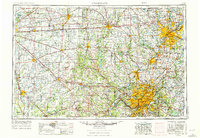
1953 Map of Cincinnati
USGS Topo · Published 1976About this map
The Ohio River corridor serves as the industrial and transit anchor of this region, where the urban centers of Cincinnati and Covington face one another across the state line. By the early 1970s, the landscape reflects a transition toward large-scale infrastructure and flood control, evidenced by the presence of the Brookville Reservoir and Geist Reservoir. Transport networks define the tri-state area, with the Penn Central railroad and I-75 connecting the manufacturing hubs of Dayton and Hamilton to the river valley.
Find a feature on this map
87 named features on this map. Tap any name to fly to it.
Don’t see what you’re looking for? This feature index may not catch every label — zoom into the map to look around manually.
Map Details
Editions of this 1953 Cincinnati Map
3 editions found

Other maps of this area

1898 · East Cincinnati
USGS Topo · 1:62,500

1904 · Springfield
USGS Topo · 1:62,500

1904 · Dayton
USGS Topo · 1:62,500

1904 · Mason
USGS Topo · 1:62,500

1905 · Brookville
USGS Topo · 1:62,500

1906 · Dayton
USGS Topo · 1:62,500

1906 · Mason
USGS Topo · 1:62,500

1906 · Springfield
USGS Topo · 1:62,500

1907 · Blanchester
USGS Topo · 1:62,500

1908 · Miamisburg
USGS Topo · 1:62,500