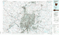
1986 Map of Cincinnati
USGS Topo · Published 1986About this map
The Ohio River serves as the focal point for this mid-1980s regional survey, where the borders of Ohio, Indiana, and Kentucky converge. The urban core of Cincinnati is depicted in dense detail, showing its expansion outward toward satellite communities like Hamilton and Middletown to the north and Covington and Newport across the river to the south. This era is characterized by a mature interstate system, featuring the I-275 beltway that rings the metropolitan area, connecting diverse landscapes from the industrialized riverfront to the growing suburbs of Clermont County.
Find a feature on this map
181 named features on this map. Tap any name to fly to it.
Don’t see what you’re looking for? This feature index may not catch every label — zoom into the map to look around manually.
Map Details
Editions of this 1986 Cincinnati Map
3 editions found
Other maps of this area

1898 · East Cincinnati
USGS Topo · 1:62,500

1904 · Mason
USGS Topo · 1:62,500

1906 · Mason
USGS Topo · 1:62,500

1907 · Blanchester
USGS Topo · 1:62,500

1908 · Miamisburg
USGS Topo · 1:62,500

1911 · Oxford
USGS Topo · 1:62,500

1913 · Waynesville
USGS Topo · 1:62,500

1914 · East Cincinnati
USGS Topo · 1:62,500

1914 · West Cincinnati
USGS Topo · 1:62,500

1914 · Batavia
USGS Topo · 1:48,000