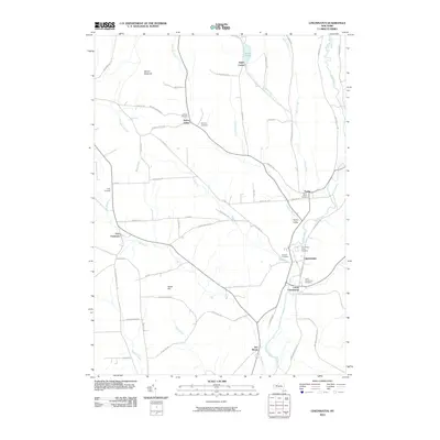
2010 Map of Cincinnatus
USGS Topo · Published 2010About this map
The Otselic River and Chenango Creek valley systems define the rural character of this region in central New York. Small clusters of historical settlement are concentrated along the riverbanks and major junctions, most notably in Cincinnatus and Lower Cincinnatus, where the river loop is flanked by several significant burial grounds including the Cincinnatus Rural Cemetery and Lower Cincinnatus Cemetery. The surrounding landscape is a network of named heights like Mount Roderick and Dutch Hill, interspersed with small brooks such as Pritchard Brook and Mead Brook. For genealogists and local historians, this survey provides precise locations for numerous family and community landmarks, from the Holmes Cemetery near the river to the upland Holland Cemetery and Hawley Cemetery in Taylor Valley. The layout of the road network, including historic routes like Telephone Rd and Piety Hill Rd, reflects the area's agricultural and township-based development.
Find a feature on this map
68 named features on this map. Tap any name to fly to it.
Don’t see what you’re looking for? This feature index may not catch every label — zoom into the map to look around manually.
Map Details
Editions of this 2010 Cincinnatus Map
This is the sole edition of this map. No revisions or reprints were ever made.
Other maps of this area

1903 · Cortland
USGS Topo · 1:62,500

1903 · Harford
USGS Topo · 1:62,500

1904 · Greene
USGS Topo · 1:62,500

1904 · Pitcher
USGS Topo · 1:62,500

1906 · Catatonk
USGS Topo · 1:125,000

1943 · South Ostelic
USGS Topo · 1:24,000

1943 · Cincinnatus
USGS Topo · 1:24,000

1943 · Cuyler
USGS Topo · 1:24,000

1943 · Pitcher
USGS Topo · 1:24,000
1944 · Cuyler
USGS Topo · 1:31,680