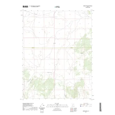
2023 Map of Cinder Crater
USGS Topo · Published 2023About this map
Cinder Crater defines the high-desert topography of this region, which straddles the boundary between Millard and Beaver counties. The landscape is characterized by its significant geologic formations and water management features like the Danish Reservoir on Cove Creek. Transport across this arid terrain is facilitated by historical routes such as Black Rock Rd and the long-established path from Cunningham to Pine Creek. Along the western edge, the Mineral Mountains rise sharply, creating a complex series of drainage systems including Water Canyon and Fourmile Canyon. These features, alongside the prominent Fourmile Ridge, illustrate the challenges of 21st-century land use in a region defined by its volcanic history and strategic water sources like Horse Flat.
Find a feature on this map
12 named features on this map. Tap any name to fly to it.
Don’t see what you’re looking for? This feature index may not catch every label — zoom into the map to look around manually.
Map Details
Editions of this 2023 Cinder Crater Map
This is the sole edition of this map. No revisions or reprints were ever made.
Other maps of this area

1885 · Beaver
USGS Topo · 1:250,000

1953 · Richfield
USGS Topo · 1:250,000

1954 · Beaver NE
USGS Topo · 1:24,000

1958 · Richfield
USGS Topo · 1:250,000

1958 · Beaver
USGS Topo · 1:62,500

1958 · Adamsville
USGS Topo · 1:62,500

1962 · Cove Fort
USGS Topo · 1:62,500

1973 · Pinnacle Pass
USGS Topo · 1:24,000

1973 · Antelope Spring
USGS Topo · 1:24,000
1980 · Beaver
USGS Topo · 1:100,000