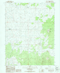
1986 Map of Cinder Crater
USGS Topo · Published 1986About this map
Cinder Crater and the surrounding volcanic landscape dominate this high-desert terrain along the Millard Co Beaver Co line. Mapping in the mid-1980s reveals a region defined by geological exploration and water management, evidenced by the presence of Danish Reservoir and several Prospects scattered across the sage and cedar-flecked hills. The sheet captures the transition from the broad, flat expanses of Horse Flat to the more broken geography of Fourmile Ridge and Cedar Grove. Extraction activity is a visible part of the local economy, with several Cinder Pits and a Gravel Pit noted near the winding path of Cove Creek. This area serves as a rugged intersection of ranching and resource scouting, where unimproved trails lead to remote landmarks like the Corral and various unnamed Prospect sites.
Find a feature on this map
16 named features on this map. Tap any name to fly to it.
Don’t see what you’re looking for? This feature index may not catch every label — zoom into the map to look around manually.
Map Details
Editions of this 1986 Cinder Crater Map
This is the sole edition of this map. No revisions or reprints were ever made.
Other maps of this area

1885 · Beaver
USGS Topo · 1:250,000

1953 · Richfield
USGS Topo · 1:250,000

1954 · Beaver NE
USGS Topo · 1:24,000

1958 · Richfield
USGS Topo · 1:250,000

1958 · Beaver
USGS Topo · 1:62,500

1958 · Adamsville
USGS Topo · 1:62,500

1962 · Cove Fort
USGS Topo · 1:62,500

1973 · Pinnacle Pass
USGS Topo · 1:24,000

1973 · Antelope Spring
USGS Topo · 1:24,000
1980 · Beaver
USGS Topo · 1:100,000