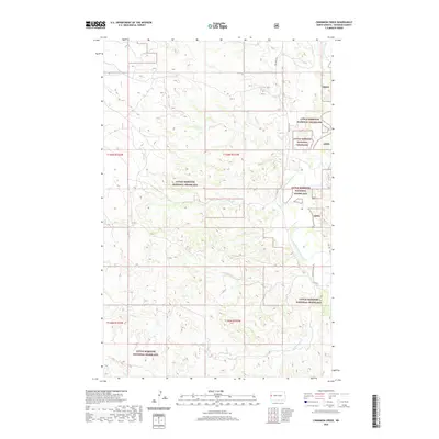
2020 Map of Cinnamon Creek
USGS Topo · Published 2020About this map
The Little Missouri National Grassland encompasses this corner of McKenzie County, where the high plains are deeply dissected by a dense network of seasonal drainages. The Little Missouri River carves a winding path through the northeastern corner, its valley fed by various tributaries including Poker Jim Cr, French Cr, and Bear Cr. The landscape is defined by the complex topography of the North Dakota Badlands, where the land falls away from high plateaus into intricate draws and coulees. Human infrastructure is limited to a few arterial routes like Red Wing Rd and Cinnamon Creek Rd, and the presence of scattered section markers like Lmng. The map captures the specialized land management of the Grassland, where the terrain is dictated by the erosive forces of Horse Cr, Cinnamon Cr, and Six Cr.
Find a feature on this map
16 named features on this map. Tap any name to fly to it.
Don’t see what you’re looking for? This feature index may not catch every label — zoom into the map to look around manually.
Map Details
Editions of this 2020 Cinnamon Creek Map
This is the sole edition of this map. No revisions or reprints were ever made.
Other maps of this area

1953 · Watford City
USGS Topo · 1:250,000

1957 · Watford City
USGS Topo · 1:250,000

1967 · Watford City
USGS Topo · 1:250,000

1970 · Eagle Draw
USGS Topo · 1:24,000

1970 · Hanks Gully
USGS Topo · 1:24,000

1972 · Sheep Creek
USGS Topo · 1:24,000
1972 · Burning Mine Butte
USGS Topo · 1:24,000

1974 · Trotters SE
USGS Topo · 1:24,000
1974 · Ice Box Canyon
USGS Topo · 1:24,000
1974 · Cinnamon Creek
USGS Topo · 1:24,000