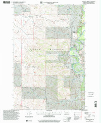
1997 Map of Cinnamon Creek
USGS Topo · Published 2001About this map
Little Missouri National Grassland dominates this corner of McKenzie County, characterized by a complex network of seasonal drainage and rugged breaks. The Little Missouri River snakes through the eastern portion of the sheet, serving as the primary geographical anchor for several private holdings. Scattered rangeland operations like the S. Larson Ranch, the Wisness Ranch, and the L Nelson property are established near the river's valley and its various tributaries.
Find a feature on this map
20 named features on this map. Tap any name to fly to it.
Don’t see what you’re looking for? This feature index may not catch every label — zoom into the map to look around manually.
Map Details
Editions of this 1997 Cinnamon Creek Map
This is the sole edition of this map. No revisions or reprints were ever made.
Other maps of this area

1953 · Watford City
USGS Topo · 1:250,000

1957 · Watford City
USGS Topo · 1:250,000

1967 · Watford City
USGS Topo · 1:250,000

1970 · Eagle Draw
USGS Topo · 1:24,000

1970 · Hanks Gully
USGS Topo · 1:24,000

1972 · Sheep Creek
USGS Topo · 1:24,000
1972 · Burning Mine Butte
USGS Topo · 1:24,000

1974 · Trotters SE
USGS Topo · 1:24,000
1974 · Ice Box Canyon
USGS Topo · 1:24,000
1974 · Cinnamon Creek
USGS Topo · 1:24,000