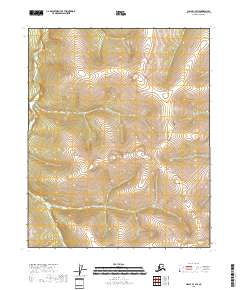
2018 Map of Circle C-4 SW
USGS Topo · Published 2018About this map
Preacher Creek winds through the western edge of this interior Alaska quadrangle, carving a path through a landscape defined by significant topographic variation. The elevation changes depicted across the t9n r8e and t9n r9e survey townships suggest a drainage system feeding from high ridges into the valley floor. To the south, McKinley Cr flows through the central portion of the sheet, providing a primary drainage point within the t8n r9e township area. The survey highlights the remote character of the Yukon-Koyukuk Census Area, where the land remains largely untracked by roads or settlements, focusing instead on the natural hydrography and the complex contouring of the uplands. This 2018 record is essential for understanding the physical geography and hydrology of this uninhabited wilderness area.
Find a feature on this map
9 named features on this map. Tap any name to fly to it.
Don’t see what you’re looking for? This feature index may not catch every label — zoom into the map to look around manually.
Map Details
Editions of this 2018 Circle C-4 SW Map
This is the sole edition of this map. No revisions or reprints were ever made.
Other maps of this area

1951 · Circle
USGS Topo · 1:250,000

1952 · Circle B-4
USGS Topo · 1:63,360

1952 · Circle C-4
USGS Topo · 1:63,360

1952 · Circle C-5
USGS Topo · 1:63,360

1954 · Circle C-5
USGS Topo · 1:63,360

1954 · Circle B-5
USGS Topo · 1:63,360

1955 · Circle
USGS Topo · 1:250,000

1964 · Circle
USGS Topo · 1:250,000
2018 · Circle B-5 NE
USGS Topo · 1:25,000
2018 · Circle C-5 NE
USGS Topo · 1:25,000