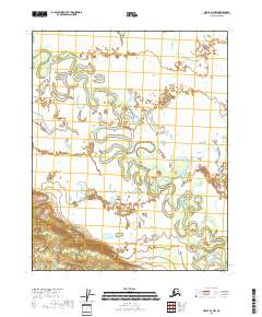
2018 Map of Circle D-1 NW
USGS Topo · Published 2018About this map
Birch Creek meanders through this vast wetland landscape in the Yukon-Koyukuk Census Area, forming an intricate network of oxbows and recursive loops across the interior of Alaska. The terrain is defined by low-lying marshlands and subtle elevation changes, where the water system dictates the local geography. Bog Lake sits as a primary landmark within this aquatic labyrinth, surrounded by unnamed ponds and smaller sloughs. Surveyed in the late 2010s, this map captures a snapshot of the subarctic environment where the land is constantly reshaped by the seasonal flow and shifting banks of the creek. The grid lines of the Public Land Survey System, including t13n r16e, overlay this wilderness, providing a coordinate-based reference for an area devoid of roads or settlements.
Find a feature on this map
8 named features on this map. Tap any name to fly to it.
Don’t see what you’re looking for? This feature index may not catch every label — zoom into the map to look around manually.
Map Details
Editions of this 2018 Circle D-1 NW Map
This is the sole edition of this map. No revisions or reprints were ever made.
Other maps of this area

1951 · Fort Yukon
USGS Topo · 1:250,000

1951 · Circle
USGS Topo · 1:250,000

1952 · Circle D-2
USGS Topo · 1:63,360

1955 · Circle D-1
USGS Topo · 1:63,360

1955 · Circle
USGS Topo · 1:250,000

1956 · Fort Yukon A-2
USGS Topo · 1:63,360

1956 · Fort Yukon A-1
USGS Topo · 1:63,360

1956 · Fort Yukon
USGS Topo · 1:250,000

1964 · Circle
USGS Topo · 1:250,000
1966 · Fort Yukon A-2
USGS Topo · 1:63,360