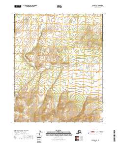
2018 Map of Circle D-3 SE
USGS Topo · Published 2018About this map
The Little Crazy Mountains dominate the northeastern portion of this topographic survey, illustrating a landscape defined by dramatic elevation changes in the Alaska interior. This specific quadrant of the Yukon-Koyukuk Census Area reveals the headwaters and drainage of Mule Cr, which winds through the central and southern reaches of the map. The terrain is characterized by extensive wetlands and high-altitude contours, as indicated by the National Wetlands Inventory and the National Elevation Dataset. The lack of modern road infrastructure underscores the remote nature of this wilderness area within the t12n r12e and t11n r13e townships. The map provides a precise look at the drainage patterns and land-survey grids that define these roadless highlands in the early twenty-first century.
Find a feature on this map
6 named features on this map. Tap any name to fly to it.
Don’t see what you’re looking for? This feature index may not catch every label — zoom into the map to look around manually.
Map Details
Editions of this 2018 Circle D-3 SE Map
This is the sole edition of this map. No revisions or reprints were ever made.
Other maps of this area

1951 · Circle
USGS Topo · 1:250,000

1952 · Circle D-3
USGS Topo · 1:63,360

1952 · Circle D-2
USGS Topo · 1:63,360

1955 · Circle C-3
USGS Topo · 1:63,360

1955 · Circle C-2
USGS Topo · 1:63,360

1955 · Circle
USGS Topo · 1:250,000

1964 · Circle
USGS Topo · 1:250,000
2018 · Circle D-2 SW
USGS Topo · 1:25,000
2018 · Circle D-3 NE
USGS Topo · 1:25,000
2018 · Circle D-2 NW
USGS Topo · 1:25,000