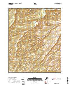
2018 Map of Circle D-4 NE
USGS Topo · Published 2018About this map
Discovery Creek provides the primary drainage through this interior Alaskan wilderness within the Yukon-Koyukuk Census Area. The landscape is defined by its topographic complexity, where a series of rounded ridges and high-elevation basins are mapped in detail using 10-foot contours. As part of a 2018 survey, this sheet provides a high-resolution view of the local hydrology and land divisions, including portions of t14n r10e, t13n r10e, and t12n r10e. For those studying the environmental history or looking to navigate the backcountry of the Circle region, the map documents the intricate network of seasonal drainage patterns and the specific elevation profiles of the unnamed peaks and valleys surrounding the creek basin.
Find a feature on this map
9 named features on this map. Tap any name to fly to it.
Don’t see what you’re looking for? This feature index may not catch every label — zoom into the map to look around manually.
Map Details
Editions of this 2018 Circle D-4 NE Map
This is the sole edition of this map. No revisions or reprints were ever made.
Other maps of this area

1951 · Fort Yukon
USGS Topo · 1:250,000

1951 · Circle
USGS Topo · 1:250,000

1952 · Circle D-4
USGS Topo · 1:63,360

1952 · Circle D-3
USGS Topo · 1:63,360

1955 · Circle
USGS Topo · 1:250,000

1956 · Fort Yukon A-4
USGS Topo · 1:63,360
1956 · Fort Yukon A-3
USGS Topo · 1:63,360

1956 · Fort Yukon
USGS Topo · 1:250,000

1964 · Circle
USGS Topo · 1:250,000
1966 · Fort Yukon A-4
USGS Topo · 1:63,360