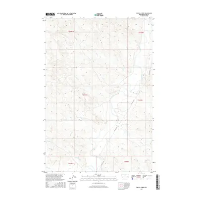
2017 Map of Circle L Creek
USGS Topo · Published 2017About this map
The Tongue River meanders through this portion of Custer County, shaping a drainage system defined by numerous seasonal and perennial tributaries. The eponymous Circle L Creek enters the river from the west, part of a network of waterways including Wolf Cr, Nelson Cr, and Thorpe Cr that have carved the undulating topography of the Montana plains. Human presence is concentrated along the primary transit corridor, Tongue River Rd, which follows the river's eastern bank through the township sections of T5N R48E and T6N R48E. This 2017 survey illustrates the persistence of traditional land divisions and the vital importance of water access in this pastoral landscape, where the confluence of smaller streams like Dry Cr and Kennedy Cr with the main river channel dictates the movement of cattle and commerce.
Find a feature on this map
15 named features on this map. Tap any name to fly to it.
Don’t see what you’re looking for? This feature index may not catch every label — zoom into the map to look around manually.
Map Details
Editions of this 2017 Circle L Creek Map
This is the sole edition of this map. No revisions or reprints were ever made.
Other maps of this area

1953 · Miles City
USGS Topo · 1:250,000

1957 · Miles City
USGS Topo · 1:250,000

1958 · Miles City
USGS Topo · 1:250,000

1968 · Lignite Creek
USGS Topo · 1:24,000

1968 · Paddy Fay Creek
USGS Topo · 1:24,000
1969 · Jack Creek NW
USGS Topo · 1:24,000

1969 · Horse Creek
USGS Topo · 1:24,000

1969 · Circle L Creek
USGS Topo · 1:24,000

1969 · Beebe SW
USGS Topo · 1:24,000
1969 · Whitney Creek
USGS Topo · 1:24,000