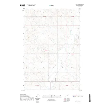
2020 Map of Circle L Creek
USGS Topo · Published 2020About this map
The Tongue River valley carves through the heart of this Custer County landscape, defining the local geography and transport patterns of eastern Montana. Flowing generally northward, the river is the primary drainage for a network of intermittent streams, including Wolf Cr and the namesake Circle L Cr. These waterways create a complex series of draws and ridges that characterize the terrain. Along the eastern bank, the Tongue River Rd follows the natural contours of the valley, providing the primary north-south connection for this ranching and grazing country. The map captures the organized layout of the Public Land Survey System, showing several townships such as t5n r47e and t5n r48e, which historically partitioned the land for settlement. Other notable drainages appearing on this sheet include Dry Cr, Nelson Cr, and Kennedy Cr, each contributing to the highly dissected landscape typical of the region.
Find a feature on this map
16 named features on this map. Tap any name to fly to it.
Don’t see what you’re looking for? This feature index may not catch every label — zoom into the map to look around manually.
Map Details
Editions of this 2020 Circle L Creek Map
This is the sole edition of this map. No revisions or reprints were ever made.
Other maps of this area

1953 · Miles City
USGS Topo · 1:250,000

1957 · Miles City
USGS Topo · 1:250,000

1958 · Miles City
USGS Topo · 1:250,000

1968 · Lignite Creek
USGS Topo · 1:24,000

1968 · Paddy Fay Creek
USGS Topo · 1:24,000
1969 · Jack Creek NW
USGS Topo · 1:24,000

1969 · Horse Creek
USGS Topo · 1:24,000

1969 · Circle L Creek
USGS Topo · 1:24,000

1969 · Beebe SW
USGS Topo · 1:24,000
1969 · Whitney Creek
USGS Topo · 1:24,000