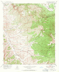
1949 Map of Circle Mesa
USGS Topo · Published 1971About this map
The rugged high-desert landscape of Circle Mesa and the surrounding Gila National Forest comes into sharp focus during this 1949 field check. The area is defined by the drainage system of Mangas Creek, which runs through the southwestern portion of the sheet parallel to Route 260. Human activity is primarily centered on isolated cattle ranching operations, with several family-named landmarks such as Allison Ranch and Sherman Ranch positioned near canyon mouths or reliable water sources like Dud Tank.
Find a feature on this map
24 named features on this map. Tap any name to fly to it.
Don’t see what you’re looking for? This feature index may not catch every label — zoom into the map to look around manually.
Map Details
Editions of this 1949 Circle Mesa Map
2 editions found
Other maps of this area

1909 · Silver City
USGS Topo · 1:125,000

1949 · Circle Mesa
USGS Topo · 1:24,000

1950 · Tyrone
USGS Topo · 1:24,000

1950 · Dorsey Ranch
USGS Topo · 1:24,000

1950 · Wind Mountain
USGS Topo · 1:24,000

1950 · Silver City
USGS Topo · 1:24,000

1950 · Reading Mountain
USGS Topo · 1:24,000

1951 · Circle Mesa
USGS Topo · 1:24,000

1951 · Dorsey Ranch
USGS Topo · 1:24,000
1951 · Silver City
USGS Topo · 1:24,000