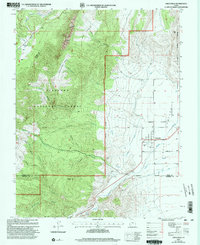
2001 Map of Circleville
USGS Topo · Published 2003About this map
Circleville sits at the heart of Circle Valley, where the agricultural landscape is defined by an intricate network of irrigation including the West Canal and an Aqueduct. This 2001 revision of earlier 1960s mapping illustrates the intersection of high mountain terrain and valley floor irrigation, capturing the town as it straddles the Sevier River. To the west, the landscape rises sharply into the Fishlake National Forest, a region marked by deep drainages like Wades Canyon and prominent landmarks such as Parker Peak. Local history is anchored by the Cem on the edge of town and the various family-named hollows and flats, such as Betenson Flat and Lums Canyon, that suggest the area's grazing and timber heritage. The map also documents industrial footprints like a Gravel Pit and the natural bottleneck of Circleville Canyon to the south.
Find a feature on this map
30 named features on this map. Tap any name to fly to it.
Don’t see what you’re looking for? This feature index may not catch every label — zoom into the map to look around manually.
Map Details
Editions of this 2001 Circleville Map
This is the sole edition of this map. No revisions or reprints were ever made.
Other maps of this area

1885 · Beaver
USGS Topo · 1:250,000

1937 · Delano Peak
USGS Topo · 1:48,000

1943 · Delano Peak
USGS Topo · 1:62,500

1945 · Marysvale
USGS Topo · 1:62,500

1947 · Marysvale
USGS Topo · 1:62,500

1953 · Richfield
USGS Topo · 1:250,000

1958 · Richfield
USGS Topo · 1:250,000

1966 · Bull Rush Peak
USGS Topo · 1:24,000

1966 · Circleville
USGS Topo · 1:24,000

1966 · Fremont Pass
USGS Topo · 1:24,000