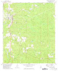
1982 Map of Citronelle East
USGS Topo · Published 1982About this map
Citronelle serves as the primary hub on this map, situated within an extensive Oil Field network that dominates the northwestern landscape. The industrial character of the early 1980s is evident in the dense concentration of Pipelines, storage facilities, and numerous extraction sites. Transportation and logistics are defined by the Illinois Central Gulf railroad corridor, which parallels the highway through Sidney and Russell. Outside the industrial zones, the land reveals a quieter, communal history through a series of rural churches and cemeteries, such as Mt Nebo Cem and Bethlehem Ch. The terrain is deeply etched by the headwaters of Cedar Creek and Little Creek, while the presence of Scoutshire Woods and the Langdon Lookout Tower near Spring Lake highlights the region's managed forests. This survey captures a moment of established petroleum production integrated with small, persistent Gulf Coast settlements.
Find a feature on this map
40 named features on this map. Tap any name to fly to it.
Don’t see what you’re looking for? This feature index may not catch every label — zoom into the map to look around manually.
Map Details
Editions of this 1982 Citronelle East Map
2 editions found
Other maps of this area

1941 · Creola
USGS Topo · 1:62,500

1942 · Deer Park
USGS Topo · 1:62,500

1942 · Wilmer
USGS Topo · 1:62,500

1943 · Creola
USGS Topo · 1:62,500

1943 · Deer Park
USGS Topo · 1:62,500

1943 · Citronelle
USGS Topo · 1:62,500

1944 · Wilmer
USGS Topo · 1:62,500

1946 · Citronelle
USGS Topo · 1:62,500

1953 · Hattiesburg
USGS Topo · 1:250,000

1953 · Mobile
USGS Topo · 1:250,000