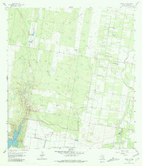
1963 Map of Citrus City
USGS Topo · Published 1980About this map
Citrus City and the surrounding Rio Grande Valley landscape appear in this early 1960s survey as a highly organized network of citrus groves and petroleum extraction. The infrastructure of Hidalgo Water Dist No 16 is evident throughout the eastern half of the quadrangle, where a series of elevated irrigation canals support the agricultural grid. To the southwest, the terrain transitions into the industrial activity of the Tabasco Oil and Gas Field, marked by numerous well sites and pumping stations. Near the edge of the Rio Grande floodplain, La Joya Lake and La Joya Creek provide a natural contrast to the geometric patterns of the orchards. Small family operations like El Veleno Ranch and Santa Rita Ranch remain interspersed among the commercial developments, while several Quarries and Gravel Pits indicate local resource extraction near the river breaks.
Find a feature on this map
12 named features on this map. Tap any name to fly to it.
Don’t see what you’re looking for? This feature index may not catch every label — zoom into the map to look around manually.
Map Details
Editions of this 1963 Citrus City Map
3 editions found
Other maps of this area

1940 · Monte Christo
USGS Topo · 1:62,500

1949 · Mc Allen
USGS Topo · 1:250,000

1954 · McAllen
USGS Topo · 1:250,000

1956 · Garcias
USGS Topo · 1:62,500

1956 · Los Ebanos
USGS Topo · 1:62,500

1957 · Mc Allen
USGS Topo · 1:250,000

1962 · McAllen
USGS Topo · 1:250,000

1963 · Monte Christo
USGS Topo · 1:24,000

1963 · La Joya
USGS Topo · 1:24,000

1963 · Citrus City
USGS Topo · 1:24,000