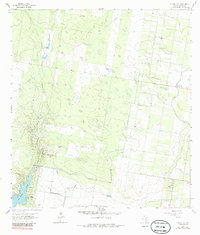
1963 Map of Citrus City
USGS Topo · Published 1985About this map
Citrus City and its surrounding ranchlands are defined by an intricate network of irrigation and resource extraction in this early 1960s survey of Hidalgo County. The arid landscape is marked by the presence of the Tabasco Oil and Gas Field, with numerous drill holes and a gas well scattered across the brush. Water management is central to the area's utility, evidenced by the Hidalgo Water Dist No 16 facilities, an aqueduct, and the La Morita Windmill. Natural features like La Joya Lake and La Joya Creek provide a contrast to the industrial footprint of gravel pits and quarries. Family-named sites like El Veneno Ranch and Santa Rita Ranch provide valuable points of reference for genealogists tracking local landholdings during this era of South Texas development.
Find a feature on this map
18 named features on this map. Tap any name to fly to it.
Don’t see what you’re looking for? This feature index may not catch every label — zoom into the map to look around manually.
Map Details
Editions of this 1963 Citrus City Map
3 editions found
Other maps of this area

1940 · Monte Christo
USGS Topo · 1:62,500

1949 · Mc Allen
USGS Topo · 1:250,000

1954 · McAllen
USGS Topo · 1:250,000

1956 · Garcias
USGS Topo · 1:62,500

1956 · Los Ebanos
USGS Topo · 1:62,500

1957 · Mc Allen
USGS Topo · 1:250,000

1962 · McAllen
USGS Topo · 1:250,000

1963 · Monte Christo
USGS Topo · 1:24,000

1963 · La Joya
USGS Topo · 1:24,000

1963 · Citrus City
USGS Topo · 1:24,000