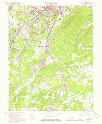
1963 Map of City Farm
USGS Topo · Published 1978About this map
Candler Mountain and Jack Mountain dominate the topography south of the Lynchburg city limits, where suburban expansion meets the rural landscape of Campbell County. The southern aviation hub at Lynchburg Municipal Airport Preston Glenn Field serves as a major focal point, while the Southern and Norfolk and Western railroads create industrial corridors through the hills. This 1963 survey, updated with late 1970s development, reveals a landscape in transition as residential subdivisions like Richland Hills and Vista Acres encroach upon older rural settlements such as Lawyers and Bocock. Local history is preserved in numerous family and community landmarks, from the Marsh Memorial Home to the Beulah Cem and Bethlehem Ch. Water bodies such as Timberlake and Rockdale Lake anchor several recreation and residential clusters amidst the network of creeks like Flat Creek and Yellow Branch.
Find a feature on this map
63 named features on this map. Tap any name to fly to it.
Don’t see what you’re looking for? This feature index may not catch every label — zoom into the map to look around manually.
Map Details
Editions of this 1963 City Farm Map
4 editions found

Other maps of this area

1892 · Lynchburg
USGS Topo · 1:125,000

1944 · Lynchburg
USGS Topo · 1:62,500

1947 · Roanoke
USGS Topo · 1:250,000

1950 · Goode
USGS Topo · 1:62,500

1950 · Lynchburg
USGS Topo · 1:62,500

1951 · Altavista
USGS Topo · 1:62,500

1956 · Gladys
USGS Topo · 1:62,500

1959 · Roanoke
USGS Topo · 1:250,000

1963 · Roanoke
USGS Topo · 1:250,000
1963 · Kelly
USGS Topo · 1:24,000