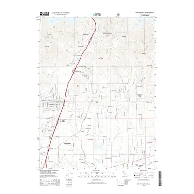
2015 Map of City of Shasta Lake
USGS Topo · Published 2015About this map
Mountain Gate serves as a central hub in this landscape north of Redding, where the foothills of the Shasta National Forest meet the expanding residential corridors of the Sacramento Valley. The map documents a dense network of suburban development and rural homesteads, evidenced by the proliferation of named roads like Wonderland Blvd and Old Oregon Trl. Local commerce and historical waypoints are marked by nodes such as Portal Inn, Tunnel Inn, and McColl, situated along the primary transportation artery leading toward Shasta Lake.
Find a feature on this map
171 named features on this map. Tap any name to fly to it.
Don’t see what you’re looking for? This feature index may not catch every label — zoom into the map to look around manually.
Map Details
Editions of this 2015 City of Shasta Lake Map
This is the sole edition of this map. No revisions or reprints were ever made.
Other maps of this area

1890 · Red Bluff
USGS Topo · 1:250,000

1894 · Red Bluff
USGS Topo · 1:250,000

1901 · Redding
USGS Topo · 1:125,000

1944 · Redding
USGS Topo · 1:62,500

1946 · Lamoine
USGS Topo · 1:62,500

1946 · Redding
USGS Topo · 1:62,500

1949 · Bollibokka Mtn
USGS Topo · 1:62,500

1953 · Millville
USGS Topo · 1:62,500
1956 · Shasta Dam
USGS Topo · 1:24,000
1957 · Redding
USGS Topo · 1:24,000