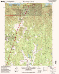
1998 Map of City of Shasta Lake
USGS Topo · Published 2003About this map
Shasta Lake anchors the northern reaches of this landscape, its shoreline defining the boundary between the Whiskeytown Shasta Trinity National Recreation Area and the Shasta Trinity National Forest. To the south, the communities of Project City, Central Valley, and the newly incorporated City of Shasta Lake showcase the mid-to-late 20th-century growth pattern of the region. This 1998 revision highlights a complex water management and transportation corridor, with Interstate 5 threading past roadside landmarks like Tunnel Inn and Portal Inn while crossing several forks of Stillwater Creek.
Find a feature on this map
48 named features on this map. Tap any name to fly to it.
Don’t see what you’re looking for? This feature index may not catch every label — zoom into the map to look around manually.
Map Details
Editions of this 1998 City of Shasta Lake Map
This is the sole edition of this map. No revisions or reprints were ever made.
Other maps of this area

1890 · Red Bluff
USGS Topo · 1:250,000

1894 · Red Bluff
USGS Topo · 1:250,000

1901 · Redding
USGS Topo · 1:125,000

1944 · Redding
USGS Topo · 1:62,500

1946 · Lamoine
USGS Topo · 1:62,500

1946 · Redding
USGS Topo · 1:62,500

1949 · Bollibokka Mtn
USGS Topo · 1:62,500

1953 · Millville
USGS Topo · 1:62,500
1956 · Shasta Dam
USGS Topo · 1:24,000
1957 · Redding
USGS Topo · 1:24,000