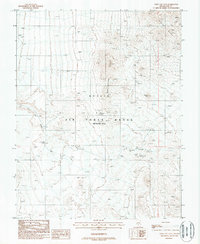
1987 Map of Civet Cat Cave
USGS Topo · Published 1988About this map
Jamestown and the historic Wellington (Site) anchor this mid-1980s look at a high-desert mining district within the Nellis Air Force Range. Located in the southern Wellington Hills and the western edge of the Cactus Range, the landscape is densely marked by prospect pits and shafts, documenting an era of intense mineral exploration. Notable workings such as the Golden Chariot Mine and the Franz Hammel Mine are visible along the rugged drainages. The topography is defined by prominent landmarks like O'Briens Knob and the geographic feature for which the quadrangle is named, Civet Cat Cave, situated near Civet Cat Canyon. This provisional survey preserves the locations of numerous unnamed mining features that reflect the region's hard-rock prospecting history before modern military restrictions reshaped access to the terrain.
Find a feature on this map
16 named features on this map. Tap any name to fly to it.
Don’t see what you’re looking for? This feature index may not catch every label — zoom into the map to look around manually.
Map Details
Editions of this 1987 Civet Cat Cave Map
This is the sole edition of this map. No revisions or reprints were ever made.
Other maps of this area

1908 · Kawich
USGS Topo · 1:250,000

1942 · Tolicha Peak
USGS Topo · 1:125,000

1942 · Cactus Range
USGS Topo · 1:125,000

1952 · Mellan
USGS Topo · 1:62,500

1952 · Cactus Spring
USGS Topo · 1:62,500
1952 · Black Mtn
USGS Topo · 1:62,500

1954 · Goldfield
USGS Topo · 1:250,000

1955 · Goldfield
USGS Topo · 1:250,000

1958 · Goldfield
USGS Topo · 1:250,000

1962 · Goldfield
USGS Topo · 1:250,000