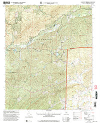
2001 Map of Clairmont Springs
USGS Topo · Published 2004About this map
Talladega Mountain and Poe Bridge Mountain dominate this landscape within the Talladega National Forest, where the terrain dictates a pattern of small settlements tucked into the valley floors. Several spring-based communities, including Clairmont Springs and Chandler Springs, highlight the area's geological character and its history as a destination for travelers. The high ridges are traversed by the Skyway Motorway and the Pinhoti Trail, offering a clear look at the recreational and fire-management infrastructure of the early 21st century.
Find a feature on this map
36 named features on this map. Tap any name to fly to it.
Don’t see what you’re looking for? This feature index may not catch every label — zoom into the map to look around manually.
Map Details
Editions of this 2001 Clairmont Springs Map
This is the sole edition of this map. No revisions or reprints were ever made.
Other maps of this area

1890 · Talladega
USGS Topo · 1:125,000

1891 · Ashland
USGS Topo · 1:125,000

1892 · Talladega
USGS Topo · 1:125,000

1943 · Talladega
USGS Topo · 1:62,500

1944 · Goodwater
USGS Topo · 1:62,500

1946 · Talladega
USGS Topo · 1:62,500

1947 · Goodwater
USGS Topo · 1:62,500

1953 · Birmingham
USGS Topo · 1:250,000

1953 · Atlanta
USGS Topo · 1:250,000

1956 · Birmingham
USGS Topo · 1:250,000