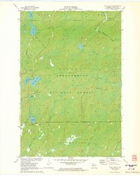
1971 Map of Clam Lake NE
USGS Topo · Published 1973About this map
The Chequamegon National Forest dominates this northern Wisconsin landscape, reflecting the heavy timber and water management priorities of the early 1970s. The terrain is defined by a dense network of glacial lakes and river systems, including the Brunsweiler River and the headwaters of the Torch River. A notable vestige of the region's industrial past is the Old RR Grade cutting through the eastern portion of the forest, south of Dingdong Creek. This feature, along with several scattered Gravel Pits, points to the infrastructure once required for logging and transport in the townships of Gordon, Morse, and Shanagolden. Recreational development is evident near the center of the map, where a Campground sits between West Twin Lake and East Twin Lake, while more isolated features like Dead Horse Slough and Spider Lake characterize the uncleared wetlands.
Find a feature on this map
30 named features on this map. Tap any name to fly to it.
Don’t see what you’re looking for? This feature index may not catch every label — zoom into the map to look around manually.
Map Details
Editions of this 1971 Clam Lake NE Map
This is the sole edition of this map. No revisions or reprints were ever made.
Other maps of this area

1942 · Glidden
USGS Topo · 1:48,000

1942 · Clam Lake
USGS Topo · 1:48,000

1942 · Mellen
USGS Topo · 1:48,000

1942 · Marengo
USGS Topo · 1:48,000

1945 · Marengo
USGS Topo · 1:48,000

1945 · Clam Lake
USGS Topo · 1:48,000

1945 · Glidden
USGS Topo · 1:48,000

1945 · Mellen
USGS Topo · 1:48,000

1953 · Ashland
USGS Topo · 1:250,000
1956 · Mellen
USGS Topo · 1:24,000