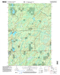
2005 Map of Clam Lake NE
USGS Topo · Published 2006About this map
The Chequamegon Nicolet National Forest dominates this northern Wisconsin landscape, revealing a densely wooded terrain defined by glacial hydrology and modern recreation. The northern edge of the Shanagolden area meets the townships of Gordon, Marengo, and Morse, where water drains through intricate systems like Spider Creek and Dingdong Creek. The map identifies specific recreational access points, including Boat Access (Carry In) at West Twin Lake and no-ramp access at East Twin Lake. Of particular interest to geography students is the Great Divide, which crests through the center of the sheet and is followed by the Great Divide Snowmobile Trail. Scattered industrial activity is noted by several Gravel Pits, while the southern reaches feature the broad wetland of Dead Horse Slough and the winding Torch River.
Find a feature on this map
25 named features on this map. Tap any name to fly to it.
Don’t see what you’re looking for? This feature index may not catch every label — zoom into the map to look around manually.
Map Details
Editions of this 2005 Clam Lake NE Map
This is the sole edition of this map. No revisions or reprints were ever made.
Other maps of this area

1942 · Glidden
USGS Topo · 1:48,000

1942 · Clam Lake
USGS Topo · 1:48,000

1942 · Mellen
USGS Topo · 1:48,000

1942 · Marengo
USGS Topo · 1:48,000

1945 · Marengo
USGS Topo · 1:48,000

1945 · Clam Lake
USGS Topo · 1:48,000

1945 · Glidden
USGS Topo · 1:48,000

1945 · Mellen
USGS Topo · 1:48,000

1953 · Ashland
USGS Topo · 1:250,000
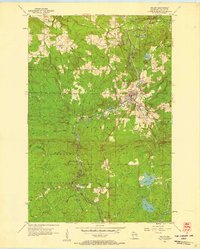
1956 · Mellen
USGS Topo · 1:24,000