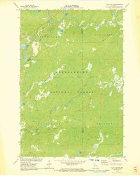
1971 Map of Clam Lake SW
USGS Topo · Published 1973About this map
The West Fork Chippewa River and its intricate network of tributaries define this section of the Chequamegon National Forest during the early 1970s. This survey, conducted in cooperation with the Wisconsin Geological and Natural History Survey, illustrates a landscape dominated by glacial water bodies and significant wetlands. Settlement patterns are sparse, represented by townships like Spider Lake, Shanagolden, and Round Lake. The map provides detailed bathymetry for several lakes, including Partridge Crop Lake and Moose Lake, reflecting a focus on the region's aquatic resources. Small-scale industrial activity is noted via a Gravel Pit near the southern edge. The terrain is marked by numerous creeks such as Fishtrap Creek, Black Creek, and Red Ike Creek, which feed into the primary river system, supporting the remote timber and recreation environment of Sawyer Co and Ashland Co.
Find a feature on this map
25 named features on this map. Tap any name to fly to it.
Don’t see what you’re looking for? This feature index may not catch every label — zoom into the map to look around manually.
Map Details
Editions of this 1971 Clam Lake SW Map
2 editions found
Other maps of this area

1942 · Clam Lake
USGS Topo · 1:48,000

1943 · Namekagon Lake
USGS Topo · 1:48,000

1944 · Draper
USGS Topo · 1:48,000

1944 · Radisson
USGS Topo · 1:48,000

1945 · Namekagon Lake
USGS Topo · 1:48,000

1945 · Clam Lake
USGS Topo · 1:48,000

1947 · Draper
USGS Topo · 1:48,000

1949 · Radisson
USGS Topo · 1:48,000

1953 · Ashland
USGS Topo · 1:250,000

1953 · Rice Lake
USGS Topo · 1:250,000