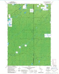
1971 Map of Clam Lake SW
USGS Topo · Published 1985About this map
Chequamegon National Forest dominates this landscape in the early 1970s, characterized by a complex network of glacial lakes and northern Wisconsin river systems. The West Fork Chippewa River meanders through the northwest, joined by tributaries such as Red Ike Creek and Christy Creek. This area, split by the boundary of Sawyer and Ashland counties, reflects the deep wilderness character of the region before significant modern development. Numerous smaller water bodies like Partridge Crop Lake, Meadow Lake, and Ike Lake are scattered across the terrain, indicating a landscape defined by its hydrology and timber resources. The presence of the BPW Wayside and various gravel pits suggests the infrastructure of the era, supporting the logging and recreational activities central to this part of the Wisconsin Northwoods. The detailed mapping of the Moose River and Little Moose River provides a precise record of these waterways before subsequent environmental changes.
Find a feature on this map
21 named features on this map. Tap any name to fly to it.
Don’t see what you’re looking for? This feature index may not catch every label — zoom into the map to look around manually.
Map Details
Editions of this 1971 Clam Lake SW Map
2 editions found
Other maps of this area

1942 · Clam Lake
USGS Topo · 1:48,000

1943 · Namekagon Lake
USGS Topo · 1:48,000

1944 · Draper
USGS Topo · 1:48,000

1944 · Radisson
USGS Topo · 1:48,000

1945 · Namekagon Lake
USGS Topo · 1:48,000

1945 · Clam Lake
USGS Topo · 1:48,000

1947 · Draper
USGS Topo · 1:48,000

1949 · Radisson
USGS Topo · 1:48,000

1953 · Ashland
USGS Topo · 1:250,000

1953 · Rice Lake
USGS Topo · 1:250,000