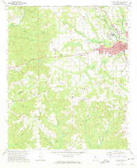
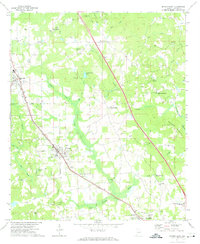
1972 Map of Clanton West
USGS Topo · Published 1974About this map
The Chilton County seat of Clanton serves as the focal point for this early 1970s survey, showing a landscape defined by the intersection of the Louisville and Nashville railroad and a network of rural watercourses. The town's grid expands westward, with civil landmarks such as the Courthouse, City Hall, and Po anchoring the center, while the County Vocational Technical Sch and a Drive-in Theater reflect the era's mid-century development. Moving away from the municipal core, the terrain is marked by numerous family and community landmarks, including the Old Liberty Hill Cem and Morning Star Ch. The drainage patterns of Mulberry Creek and its many branches, like Benson Cr and Sandy Branch, illustrate the area's transition from agricultural homesteads to more modern infrastructure, including a prominent Pipeline and a local Drag Strip.
Find a feature on this map
67 named features on this map. Tap any name to fly to it.
Don’t see what you’re looking for? This feature index may not catch every label — zoom into the map to look around manually.
Map Details
Editions of this 1972 Clanton West Map
This is the sole edition of this map. No revisions or reprints were ever made.
Other maps of this area

1891 · Clanton
USGS Topo · 1:125,000

1953 · Montgomery
USGS Topo · 1:250,000

1956 · Montgomery
USGS Topo · 1:250,000

1957 · Montgomery
USGS Topo · 1:250,000

1959 · Plantersville
USGS Topo · 1:62,500

1959 · Billingsley
USGS Topo · 1:62,500
1971 · Lay Dam
USGS Topo · 1:24,000
1971 · Maplesville East
USGS Topo · 1:24,000
1971 · Jemison West
USGS Topo · 1:24,000
1971 · Jemison East
USGS Topo · 1:24,000