
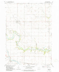
1979 Map of Clare
USGS Topo · Published 1979About this map
Clare and Barnum anchor this prairie landscape in Northwest Iowa, revealing the late 1970s intersection of rail transport and rural agriculture. The Chicago and North Western railroad passes directly through Clare, marked by a local Water Tank, while the Illinois Central Gulf line services Barnum to the south. The terrain is deeply defined by the winding course of Lizard Creek and its tributary, the South Branch Lizard Creek, which cut through the townships of Jackson and Johnson. Genealogists will find significant local value in the several documented burial grounds, including Trinity Cem, Jackson Center Cem, and St James Cem. Further east, the Jerry Rabiner Boys Home and Trinity Sch represent established community institutions near the banks of Deer Creek. The map also notes industrial activity through various Gravel Pit locations and a dedicated Gaging Sta along the river.
Find a feature on this map
24 named features on this map. Tap any name to fly to it.
Don’t see what you’re looking for? This feature index may not catch every label — zoom into the map to look around manually.
Map Details
Editions of this 1979 Clare Map
2 editions found
Other maps of this area

1923 · Lehigh
USGS Topo · 1:62,500

1923 · Fort Dodge
USGS Topo · 1:62,500

1954 · Fort Dodge
USGS Topo · 1:250,000

1957 · Fort Dodge
USGS Topo · 1:250,000

1958 · Fort Dodge
USGS Topo · 1:250,000

1965 · Moorland
USGS Topo · 1:24,000

1965 · Fort Dodge South
USGS Topo · 1:24,000

1965 · Knierim
USGS Topo · 1:24,000
1979 · Fort Dodge North
USGS Topo · 1:24,000

1979 · Humboldt
USGS Topo · 1:24,000