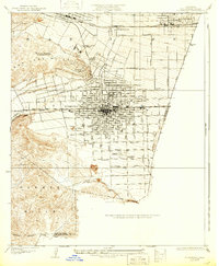
1928 Map of Claremont
USGS Topo · Published 1932About this map
Pomona emerges as a dense hub of grid-style development and regional infrastructure in this late 1920s survey. The landscape is defined by its citrus-belt heritage and the arrival of major rail lines, including the Atchison Topeka and Santa Fe and the Pacific Electric, which fueled the growth of Claremont and La Verne. The presence of the Los Angeles County Fair Grounds and Pomona College highlights the area's dual role as an agricultural center and an emerging educational corridor. Between the rugged contours of the San Jose Hills and the Puente Hills, the map documents a transition from open terrain to structured urban blocks. Local history is preserved in family and municipal landmarks like Ganesha Park and the Pomona Cemetery, alongside industrial features like the Los Angeles Co San Bernardino Co Power Line crossing the southern hills.
Find a feature on this map
47 named features on this map. Tap any name to fly to it.
Don’t see what you’re looking for? This feature index may not catch every label — zoom into the map to look around manually.
Map Details
Editions of this 1928 Claremont Map
3 editions found
Other maps of this area

1894 · Pomona
USGS Topo · 1:62,500

1896 · Anaheim
USGS Topo · 1:62,500

1897 · Pomona
USGS Topo · 1:62,500

1897 · Cucamonga
USGS Topo · 1:62,500

1898 · Pomona
USGS Topo · 1:62,500

1898 · Anaheim
USGS Topo · 1:62,500

1900 · Cucamonga
USGS Topo · 1:62,500

1901 · Southern California Sheet No. 1
USGS Topo · 1:250,000

1901 · Anaheim
USGS Topo · 1:62,500

1902 · Corona
USGS Topo · 1:125,000