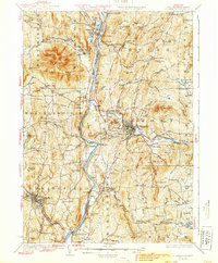
1929 Map of Claremont
USGS Topo · Published 1939About this map
The Connecticut River serves as the central artery for this late 1920s survey, dividing the Vermont and New Hampshire borderlands. On the eastern bank, Claremont emerges as a significant industrial and transit hub, anchored by the Sugar River and the Boston And Maine RR. The landscape is a network of small, specialized hamlets and family-named landmarks, from the curiously named Butcherknife Corner and Puckershire to the established agricultural grounds of the Sullivan County Farm.
Find a feature on this map
122 named features on this map. Tap any name to fly to it.
Don’t see what you’re looking for? This feature index may not catch every label — zoom into the map to look around manually.
Map Details
Editions of this 1929 Claremont Map
4 editions found

Other maps of this area

1902 · Sunapee
USGS Topo · 1:62,500

1905 · Sunapee
USGS Topo · 1:62,500

1906 · Hanover
USGS Topo · 1:62,500

1907 · Sunapee
USGS Topo · 1:62,500

1908 · Hanover
USGS Topo · 1:62,500

1911 · Woodstock
USGS Topo · 1:62,500

1913 · Woodstock
USGS Topo · 1:62,500

1926 · Claremont
USGS Topo · 1:62,500

1927 · Bellows Falls
USGS Topo · 1:48,000

1927 · Mascoma
USGS Topo · 1:62,500