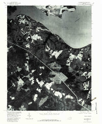
1978 Map of Claremont
USGS Topo · Published 1983About this map
Claremont sits at a strategic bend in the James River, as documented in this 1978 orthophotograph produced by the U.S. Geological Survey and the Soil Conservation Service. The landscape reveals a distinct pattern of historical riverfront estates and agricultural clearings, notably at Claremont Manor and across the water at Tettingon. The confluence of the Chickahominy River and the James dominates the northeastern portion of the sheet, while the inland terrain to the south transitions into the dense, shaded drainage of Cypress Swamp. This aerial perspective provides a literal view of the timbered reaches and cultivated fields along the Upper Chippokes Creek, illustrating the land-use patterns of Surry and Charles City counties during the late 1970s.
Find a feature on this map
7 named features on this map. Tap any name to fly to it.
Don’t see what you’re looking for? This feature index may not catch every label — zoom into the map to look around manually.
Map Details
Editions of this 1978 Claremont Map
This is the sole edition of this map. No revisions or reprints were ever made.
Other maps of this area

1917 · Toano
USGS Topo · 1:62,500

1918 · Charles City
USGS Topo · 1:62,500

1918 · Toano
USGS Topo · 1:62,500

1919 · Surry
USGS Topo · 1:62,500

1919 · Disputanta
USGS Topo · 1:62,500

1943 · Savedge
USGS Topo · 1:31,680

1943 · Richmond
USGS Topo · 1:250,000

1944 · Waverly
USGS Topo · 1:31,680

1949 · Richmond
USGS Topo · 1:250,000
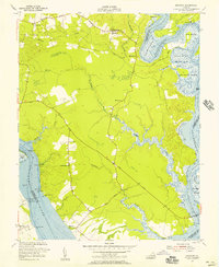
1952 · Brandon
USGS Topo · 1:24,000