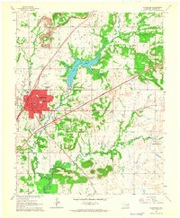
1963 Map of Claremore
USGS Topo · Published 1964About this map
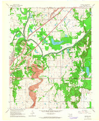
Claremore serves as a vibrant regional hub in the early 1960s, defined by its complex transportation network where the Missouri Pacific and St Louis - San Francisco railroads intersect. The town's expansion is evident in the development of the Will Rogers Turnpike and the Claremore Interchange, marking the era of increased automotive mobility and the establishment of local icons like the Service Facility Drive-in Theater. To the north, Lake Claremore and its associated Fish Hatchery provide a contrast to the industrial landscape of strip mines and numerous gravel pits scattered across the Oowala and Verdigris Hills districts.
Find a feature on this map
33 named features on this map. Tap any name to fly to it.
Don’t see what you’re looking for? This feature index may not catch every label — zoom into the map to look around manually.
Map Details
Editions of this 1963 Claremore Map
3 editions found
Other maps of this area

1896 · Pryor
USGS Topo · 1:125,000

1901 · Claremore
USGS Topo · 1:125,000

1901 · Pryor
USGS Topo · 1:125,000

1914 · Claremore
USGS Topo · 1:125,000

1916 · Claremore
USGS Topo · 1:125,000

1954 · Tulsa
USGS Topo · 1:250,000

1958 · Tulsa
USGS Topo · 1:250,000

1963 · Tulsa
USGS Topo · 1:250,000
1963 · Sageeyah
USGS Topo · 1:24,000
1963 · Catoosa
USGS Topo · 1:24,000