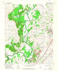
1963 Map of Sageeyah
USGS Topo · Published 1964About this map
The Verdigris River and Caney River converge in this Rogers County landscape, defining a region where early 1960s infrastructure met established rural communities. The map highlights the prominent Oklahoma Military Academy on the western edge of Claremore, serving as a major local landmark alongside the newly developed Will Rogers Turnpike. This era shows a transition in land use, as traditional farming and school districts like Sageeyah Sch and South Limestone Sch exist alongside active Oil Fields and a Strip Mine.
Find a feature on this map
32 named features on this map. Tap any name to fly to it.
Don’t see what you’re looking for? This feature index may not catch every label — zoom into the map to look around manually.
Map Details
Editions of this 1963 Sageeyah Map
3 editions found
Other maps of this area

1901 · Claremore
USGS Topo · 1:125,000

1914 · Claremore
USGS Topo · 1:125,000

1916 · Claremore
USGS Topo · 1:125,000

1954 · Tulsa
USGS Topo · 1:250,000

1955 · Mingo
USGS Topo · 1:24,000

1956 · Collinsville
USGS Topo · 1:24,000

1958 · Tulsa
USGS Topo · 1:250,000

1959 · Collinsville NE
USGS Topo · 1:24,000

1963 · Tulsa
USGS Topo · 1:250,000
1963 · Catoosa
USGS Topo · 1:24,000