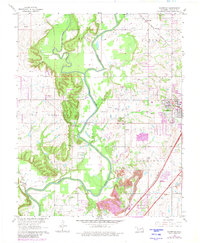
1963 Map of Sageeyah
USGS Topo · Published 1980About this map
The Verdigris River and Caney River define the physical layout of this Rogers County landscape, where the confluence and surrounding floodplains meet the rising terrain of Oolagah and Oowala. Industrial and agricultural patterns are deeply etched into the land, visible through the numerous oil wells scattered across the northern sections and the extensive gravel pits and a strip mine concentrated near the urban edge of Claremore. Transportation is a central theme, with the St Louis-San Francisco and Missouri Pacific railroads navigating the river valleys alongside the modern path of the Will Rogers Turnpike. Community life is anchored by local landmarks such as Lone Elm Ch and the Sageeyah Sch, while the presence of Claremore Jr College indicates the town's growth as a regional center during this early 1960s period.
Find a feature on this map
29 named features on this map. Tap any name to fly to it.
Don’t see what you’re looking for? This feature index may not catch every label — zoom into the map to look around manually.
Map Details
Editions of this 1963 Sageeyah Map
3 editions found
Other maps of this area

1901 · Claremore
USGS Topo · 1:125,000

1914 · Claremore
USGS Topo · 1:125,000

1916 · Claremore
USGS Topo · 1:125,000

1954 · Tulsa
USGS Topo · 1:250,000

1955 · Mingo
USGS Topo · 1:24,000

1956 · Collinsville
USGS Topo · 1:24,000

1958 · Tulsa
USGS Topo · 1:250,000

1959 · Collinsville NE
USGS Topo · 1:24,000

1963 · Tulsa
USGS Topo · 1:250,000
1963 · Sageeyah
USGS Topo · 1:24,000