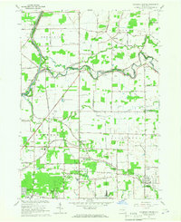
1965 Map of Clarence Center
USGS Topo · Published 1967About this map
Tonawanda Creek carves a winding path through the border between Niagara and Erie counties, serving as the primary geographic anchor for this mid-century landscape. The area is defined by a dense network of drainage, where Black Creek, Mud Creek, and Ransom Creek flow through small farming communities and growing suburban developments. Long-standing local landmarks include several country parishes such as St Marys Ch in Swormville and St Stephens Ch further east. Along the western edge, the Erie Canal remains a prominent feature, including the Sulphur Springs Guard Lock. Traces of earlier transportation are visible in the New York Central Railroad Grade, which runs through the southern portion of the quadrangle. Small airfields like Amherst Airport and Steffen Airport dot the map, reflecting the mid-1960s era of local aviation and transition from traditional agriculture to residential expansion in townships like Amherst and Clarence.
Find a feature on this map
84 named features on this map. Tap any name to fly to it.
Don’t see what you’re looking for? This feature index may not catch every label — zoom into the map to look around manually.
Map Details
Editions of this 1965 Clarence Center Map
This is the sole edition of this map. No revisions or reprints were ever made.
Other maps of this area

1894 · Buffalo
USGS Topo · 1:62,500

1897 · Tonawanda
USGS Topo · 1:62,500

1897 · Lockport
USGS Topo · 1:62,500

1899 · Niagara
USGS Topo · 1:125,000

1900 · Tonawanda
USGS Topo · 1:62,500

1901 · Buffalo
USGS Topo · 1:62,500

1901 · Tonawanda
USGS Topo · 1:62,500

1902 · Lockport
USGS Topo · 1:62,500

1905 · Depew
USGS Topo · 1:62,500

1905 · Lockport
USGS Topo · 1:62,500