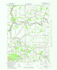
1980 Map of Clarence Center
USGS Topo · Published 1980About this map
Tonawanda Creek winds across this 1980 landscape, serving as the border between Niagara and Erie counties. The map captures the suburban and rural character of Amherst and Clarence at a time when older agricultural footprints were meeting newer developments like Ransom Oaks and Woodstream Farms. Significant aviation and transportation history is visible through the presence of Transit Air Park Inc, Steffen Airport, and the Potoczak Airport, alongside the enduring path of the Erie Canal near the Sulphur Springs Guard Lock. Local community life is well-documented through a dense network of country schools and churches, including St Marys Sch, Good Shepherd Sch, and Trinity Ch. The map also preserves the path of an Old Railroad Grade running through East Amherst and Clarence Center, a vital piece of industrial infrastructure for local genealogists and historians tracking the region's rail heritage.
Find a feature on this map
66 named features on this map. Tap any name to fly to it.
Don’t see what you’re looking for? This feature index may not catch every label — zoom into the map to look around manually.
Map Details
Editions of this 1980 Clarence Center Map
This is the sole edition of this map. No revisions or reprints were ever made.
Other maps of this area

1894 · Buffalo
USGS Topo · 1:62,500

1897 · Tonawanda
USGS Topo · 1:62,500

1897 · Lockport
USGS Topo · 1:62,500

1899 · Niagara
USGS Topo · 1:125,000

1900 · Tonawanda
USGS Topo · 1:62,500

1901 · Buffalo
USGS Topo · 1:62,500

1901 · Tonawanda
USGS Topo · 1:62,500

1902 · Lockport
USGS Topo · 1:62,500

1905 · Depew
USGS Topo · 1:62,500

1905 · Lockport
USGS Topo · 1:62,500