
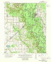
1941 Map of Clarendon
USGS Topo · Published 1946About this map
The White River and Cache River converge just below Clarendon, defining a landscape of complex waterways and seasonal river landings in the early 1940s. This survey by the Corps of Engineers details the intricate bottomlands of the Mississippi River Commission's flood control district, where numerous points like Sycamore Pt and The 90 Pt reach into the winding channels. Transport relies on the St Louis Southwestern railroad and historic river crossings such as Preston Ferry. Away from the riverbanks, the map reveals a network of rural community centers, including Roe and Ulm, alongside small rural institutions like Stahley Sch and Bethlehem Sch & Ch. The transition from the dense timber of Holly Tree Bend to the prairie lands of Monroe Prairie illustrates the diverse terrain of this Arkansas delta region during the mid-twentieth century.
Find a feature on this map
67 named features on this map. Tap any name to fly to it.
Don’t see what you’re looking for? This feature index may not catch every label — zoom into the map to look around manually.
Map Details
Editions of this 1941 Clarendon Map
2 editions found
Other maps of this area

1935 · Hazen
USGS Topo · 1:62,500

1935 · Clarendon
USGS Topo · 1:62,500

1937 · Stuttgart
USGS Topo · 1:62,500

1939 · Indian Bay
USGS Topo · 1:62,500

1939 · Stuttgart
USGS Topo · 1:62,500

1940 · Holly Grove
USGS Topo · 1:62,500

1940 · Brinkley
USGS Topo · 1:62,500

1941 · Hazen
USGS Topo · 1:62,500

1941 · De Witt
USGS Topo · 1:62,500

1941 · De Valls Bluff
USGS Topo · 1:62,500