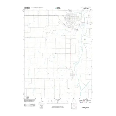
2010 Map of Clarinda South
USGS Topo · Published 2010About this map
Clarinda serves as the focal point of this southwestern Iowa landscape, situated where the North Branch West Nodaway River and South Branch West Nodaway River converge. The town's grid is anchored by the Clarinda Post Office and the Page County 4-H Fairgrounds, reflecting its role as a regional center for agriculture and commerce. To the south, the settlement of Shambaugh sits along the West Nodaway River, while College Springs occupies the southwestern corner. The surrounding countryside is marked by a network of rural roads such as 250 St and 280 St, punctuated by several family and community burial grounds, including the Covenanter Cemetery and Lee Grove Cemetery. The presence of the Clarinda Municipal Airport and the Schenck Landing Strip near Schenck Lake highlights the local aviation infrastructure integrated into this farming heartland.
Find a feature on this map
40 named features on this map. Tap any name to fly to it.
Don’t see what you’re looking for? This feature index may not catch every label — zoom into the map to look around manually.
Map Details
Editions of this 2010 Clarinda South Map
This is the sole edition of this map. No revisions or reprints were ever made.
Other maps of this area

1940 · Coin
USGS Topo · 1:62,500

1940 · New Market
USGS Topo · 1:62,500

1943 · Coin
USGS Topo · 1:62,500

1943 · New Market
USGS Topo · 1:62,500

1955 · Nebraska City
USGS Topo · 1:250,000

1957 · Nebraska City
USGS Topo · 1:250,000

1958 · Nebraska City
USGS Topo · 1:250,000

1978 · Stanton SW
USGS Topo · 1:24,000

1978 · Clarinda North
USGS Topo · 1:24,000
1980 · Hopkins SW
USGS Topo · 1:24,000