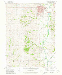
1981 Map of Clarinda South
USGS Topo · Published 1981About this map
Clarinda serves as the regional hub in this early 1980s landscape, where the confluence of several streams and industrial footprints define the town's perimeter. The East Nodaway River flows along the eastern edge, bordered by specialized infrastructure such as the Waterworks, the Fairground, and the Clarinda Municipal Airport. The mapping reveals the transition of local transportation, showing the Burlington Northern tracks alongside an Old Railroad Grade that speaks to earlier rail alignments through the southern Iowa countryside.
Find a feature on this map
40 named features on this map. Tap any name to fly to it.
Don’t see what you’re looking for? This feature index may not catch every label — zoom into the map to look around manually.
Map Details
Editions of this 1981 Clarinda South Map
This is the sole edition of this map. No revisions or reprints were ever made.
Other maps of this area

1940 · Coin
USGS Topo · 1:62,500

1940 · New Market
USGS Topo · 1:62,500

1943 · Coin
USGS Topo · 1:62,500

1943 · New Market
USGS Topo · 1:62,500

1955 · Nebraska City
USGS Topo · 1:250,000

1957 · Nebraska City
USGS Topo · 1:250,000

1958 · Nebraska City
USGS Topo · 1:250,000

1978 · Stanton SW
USGS Topo · 1:24,000

1978 · Clarinda North
USGS Topo · 1:24,000
1980 · Hopkins SW
USGS Topo · 1:24,000