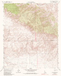
1960 Map of Clark Lake NE
USGS Topo · Published 1987About this map
The Santa Rosa Mountains dominate the upper elevations of this terrain, transitioning sharply into the low-lying Clark Valley. This 1960 field-checked survey reveals a remote landscape defined by deep drainages like Martinez Canyon and Rockhouse Canyon. Human presence is sparse, marked only by isolated features such as a Shack and Ruins in the southern flats, indicating a hardscrabble history of desert habitation. Much of the southern portion of the quadrangle is protected within the Anza-Borrego Desert State Park, where the State Park Boundary meets the Riverside Co San Diego Co line. Transportation is limited to primitive paths like the Cactus Spring Trail and various unnamed Jeep Trails, highlighting the isolation of the region before modern access improved.
Find a feature on this map
13 named features on this map. Tap any name to fly to it.
Don’t see what you’re looking for? This feature index may not catch every label — zoom into the map to look around manually.
Map Details
Editions of this 1960 Clark Lake NE Map
4 editions found
Other maps of this area

1904 · Indio
USGS Topo · 1:125,000

1931 · Vallecito
USGS Topo · 1:125,000

1941 · Toro Peak
USGS Topo · 1:62,500

1941 · Clark Lake
USGS Topo · 1:62,500

1941 · Coachella
USGS Topo · 1:62,500

1942 · Agua Dulce
USGS Topo · 1:62,500

1942 · Clark Lake
USGS Topo · 1:62,500

1943 · Vallecito
USGS Topo · 1:125,000

1943 · Coachella
USGS Topo · 1:62,500

1944 · Agua Dulce
USGS Topo · 1:62,500