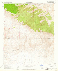
1960 Map of Clark Lake NE
USGS Topo · Published 1961About this map
The Santa Rosa Mountains dominate the northern half of this 1960 survey, their steep slopes giving way to the broad expanse of Clark Valley to the south. This arid landscape is largely defined by the sprawling boundary of Anza Borrego Desert State Park, which encompasses much of the southern terrain and the lower reaches of drainage systems like Rockhouse Canyon and Butler Canyon. Human presence is sparse, marked primarily by primitive transit routes such as the Cactus Spring Foot Trail and the Rockhouse Trail, alongside a few isolated structures including a Shack and unidentified Ruins tucked near the canyon walls. The map reveals a transition between Riverside and San Diego counties, highlighting a period when the desert remained largely inaccessible, save for a few Jeep Trails and a rare spring providing water in the high desert environment.
Find a feature on this map
14 named features on this map. Tap any name to fly to it.
Don’t see what you’re looking for? This feature index may not catch every label — zoom into the map to look around manually.
Map Details
Editions of this 1960 Clark Lake NE Map
4 editions found
Other maps of this area

1904 · Indio
USGS Topo · 1:125,000

1931 · Vallecito
USGS Topo · 1:125,000

1941 · Toro Peak
USGS Topo · 1:62,500

1941 · Clark Lake
USGS Topo · 1:62,500

1941 · Coachella
USGS Topo · 1:62,500

1942 · Agua Dulce
USGS Topo · 1:62,500

1942 · Clark Lake
USGS Topo · 1:62,500

1943 · Vallecito
USGS Topo · 1:125,000

1943 · Coachella
USGS Topo · 1:62,500

1944 · Agua Dulce
USGS Topo · 1:62,500