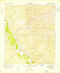
1949 Map of Clark Ranch
USGS Topo · Published 1949About this map
The San Pedro River valley in Pinal County serves as the central artery for this late-1940s landscape, where ranching and resource extraction converge. The eponymous Clark Ranch and nearby Clark School anchor the local community, while industrial activity is evidenced by a Smelter located near Cottonwood Wash. The terrain is defined by complex drainage systems and hydrothermal activity, including an Artesian Well (Hot) and an Artesian Well (Warm) along the river's eastern bank.
Find a feature on this map
26 named features on this map. Tap any name to fly to it.
Don’t see what you’re looking for? This feature index may not catch every label — zoom into the map to look around manually.
Map Details
Editions of this 1949 Clark Ranch Map
2 editions found

Other maps of this area

1911 · Winkelman
USGS Topo · 1:125,000

1913 · Winkelman
USGS Topo · 1:125,000

1938 · Galiuro Mts
USGS Topo · 1:48,000

1938 · Klondyke
USGS Topo · 1:48,000

1943 · Galiuro Mts
USGS Topo · 1:62,500

1943 · Klondyke
USGS Topo · 1:62,500

1948 · Clark Ranch
USGS Topo · 1:24,000

1948 · Mammoth
USGS Topo · 1:62,500

1948 · Mammoth
USGS Topo · 1:24,000

1948 · Campo Bonito
USGS Topo · 1:24,000