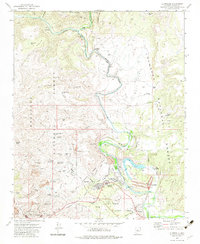
1973 Map of Clarkdale
USGS Topo · Published 1983About this map
Clarkdale serves as the industrial and residential hub of this region in the early 1970s, shaped significantly by the copper mining economy. The United Verde Mine and its associated infrastructure, including extensive Mill Tailings and Tailings Ponds, dominate the landscape west of the Verde River. The river corridor itself provides a sharp contrast, supporting the Tavasci Marsh and Pecks Lake complex. Cultural and historical sites are well-preserved, featuring the ancient Ruins of Tuzigoot Nat Mon and the Camp Verde Indian Res. Transport is defined by the Atchison Topeka and Santa Fe Railroad and an old grade that winds through the hills. This survey reveals a landscape where federal lands like the Prescott National Forest and Coconino National Forest meet the heavy industrial footprint of the Verde Valley.
Find a feature on this map
59 named features on this map. Tap any name to fly to it.
Don’t see what you’re looking for? This feature index may not catch every label — zoom into the map to look around manually.
Map Details
Editions of this 1973 Clarkdale Map
3 editions found
Other maps of this area

1887 · Verde
USGS Topo · 1:250,000

1887 · Prescott
USGS Topo · 1:250,000

1892 · Verde
USGS Topo · 1:250,000

1892 · Prescott
USGS Topo · 1:250,000

1905 · Jerome
USGS Topo · 1:125,000

1923 · Camp Verde
USGS Topo · 1:125,000

1932 · Camp Verde
USGS Topo · 1:125,000

1936 · Camp Verde
USGS Topo · 1:125,000

1944 · Clarkdale
USGS Topo · 1:48,000

1944 · Mingus Mountain
USGS Topo · 1:62,500