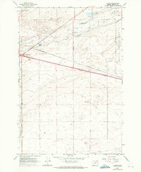
1962 Map of Clarke
USGS Topo · Published 1971About this map
The Union Pacific railroad cuts a diagonal line across this arid stretch of Morrow County, where the settlement of Clarke and the nearby Boardman Junction represent the sparse human footprint of the early 1960s. The landscape is defined by its military and industrial utility, dominated by the sprawling Umatilla Ordnance Depot on the eastern boundary and a designated Bombing Range to the south.
Find a feature on this map
18 named features on this map. Tap any name to fly to it.
Don’t see what you’re looking for? This feature index may not catch every label — zoom into the map to look around manually.
Map Details
Editions of this 1962 Clarke Map
3 editions found
Other maps of this area

1906 · Blalock Island
USGS Topo · 1:125,000

1908 · Blalock Island
USGS Topo · 1:125,000

1908 · Umatilla
USGS Topo · 1:125,000

1953 · Pendleton
USGS Topo · 1:250,000

1956 · Pendleton
USGS Topo · 1:250,000

1962 · Blalock Island
USGS Topo · 1:24,000

1962 · Ordnance
USGS Topo · 1:24,000

1962 · Paterson
USGS Topo · 1:24,000

1962 · Boardman
USGS Topo · 1:24,000

1962 · Clarke
USGS Topo · 1:24,000