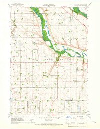
1965 Map of Clarkfield NE
USGS Topo · Published 1966About this map
The Minnesota River and Chippewa River converge in a wide, alluvial valley that dominates the northern half of this mid-1960s survey. The landscape transitions from these winding watercourses to a highly engineered agricultural plain, marked by a sophisticated drainage network including County Ditch No 90 and Judicial Ditch No 23. These systems reflect the mid-century effort to maximize the productivity of the fertile prairie lands across Camp Release and Baxter townships.
Find a feature on this map
26 named features on this map. Tap any name to fly to it.
Don’t see what you’re looking for? This feature index may not catch every label — zoom into the map to look around manually.
Map Details
Editions of this 1965 Clarkfield NE Map
This is the sole edition of this map. No revisions or reprints were ever made.
Other maps of this area

1953 · New Ulm
USGS Topo · 1:250,000

1953 · Saint Cloud
USGS Topo · 1:250,000

1957 · Saint Cloud
USGS Topo · 1:250,000

1957 · New Ulm
USGS Topo · 1:250,000

1958 · New Ulm
USGS Topo · 1:250,000

1958 · Saint Cloud
USGS Topo · 1:250,000

1958 · Milan
USGS Topo · 1:24,000

1958 · Watson
USGS Topo · 1:24,000

1958 · Gracelock SW
USGS Topo · 1:24,000

1965 · Montevideo
USGS Topo · 1:24,000