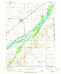
1962 Map of Clarks
USGS Topo · Published 1964About this map
The town of Clarks serves as the focal point of this Nebraska landscape, situated along the Union Pacific railroad corridor during the early 1960s. The geography is dominated by the braided channels of the Platte River, which creates a complex network of named islands including Bakers Island, Ash Island, and the larger Prairie Island. These landforms, separated by an Indefinite Boundary, illustrate the shifting nature of the river before modern stabilization. On the northern banks, Clarksville township transitions from agricultural sections to the village center, where local history is anchored by the Calvary Cem and Clarks Cem. To the south, the terrain rises toward the Bluff and the Pleasant Home district. The map captures a moment when Silver Cr and several irrigation wells supported the region's farming economy, while transportation relied on the prominent rail line and the parallel Route 30.
Find a feature on this map
22 named features on this map. Tap any name to fly to it.
Don’t see what you’re looking for? This feature index may not catch every label — zoom into the map to look around manually.
Map Details
Editions of this 1962 Clarks Map
This is the sole edition of this map. No revisions or reprints were ever made.
Other maps of this area

1896 · Stromsburg
USGS Topo · 1:125,000

1955 · Fremont
USGS Topo · 1:250,000

1957 · Fremont
USGS Topo · 1:250,000

1958 · Fremont
USGS Topo · 1:250,000

1958 · Fullerton
USGS Topo · 1:24,000

1958 · Silver Creek
USGS Topo · 1:24,000

1958 · Havens
USGS Topo · 1:24,000

1962 · Polk
USGS Topo · 1:24,000
1962 · Swedehome
USGS Topo · 1:24,000
1962 · Central City East
USGS Topo · 1:24,000