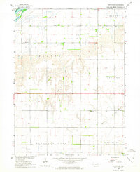
1962 Map of Swedehome
USGS Topo · Published 1964About this map
Platte River frontage defines the northwestern corner of this 1962 survey, which documents the rural landscape of Polk County during the development of the Missouri River Basin. The interior is a grid of agricultural sections dotted with vital community landmarks like Fairview Ch, Beulah Cem, and the central settlement of Swedehome. This area reflects the mid-century peak of a decentralized rural education system, preserving the locations of numbered country schools such as School No 7, School No 28, and School No 49. Waterways like Clear Creek, Prairie Creek, and Davis Cr cut through the terrain of Osceola and Stromsburg townships, showing the drainage patterns that shaped the placement of farmsteads and early roads.
Find a feature on this map
23 named features on this map. Tap any name to fly to it.
Don’t see what you’re looking for? This feature index may not catch every label — zoom into the map to look around manually.
Map Details
Editions of this 1962 Swedehome Map
This is the sole edition of this map. No revisions or reprints were ever made.
Other maps of this area

1896 · Stromsburg
USGS Topo · 1:125,000

1955 · Fremont
USGS Topo · 1:250,000

1957 · Fremont
USGS Topo · 1:250,000

1958 · Fremont
USGS Topo · 1:250,000

1958 · Silver Creek SE
USGS Topo · 1:24,000

1958 · Silver Creek
USGS Topo · 1:24,000

1958 · Havens
USGS Topo · 1:24,000

1962 · Polk
USGS Topo · 1:24,000
1962 · Clarks
USGS Topo · 1:24,000
1965 · Stromsburg
USGS Topo · 1:24,000